Key Points
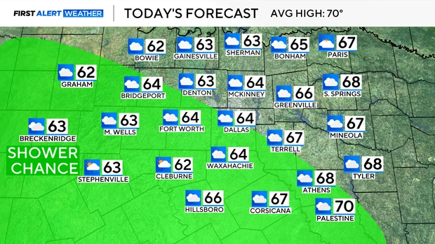
- Chilly Saturday Morning: Temperatures across North Texas dropped into the 40s early Saturday morning, with afternoon highs expected to reach the mid-60s under cloudy skies and 5 to 10 mph northeast winds.
- Western Mexico Disturbance: An upper-level low pressure system tracking from western Mexico toward central Texas is introducing a 72-hour window for scattered light rain and sprinkles.
- Rain Distribution: Rain chances for Saturday remain highest in counties west of the Dallas-Fort Worth Metroplex, while the broader region faces overcast conditions.
- Mild Overnight Lows: Cloud cover will hold overnight temperatures in the 50s, keeping Sunday morning warmer than seasonal averages before a cloudy Sunday with light winds.
- Midweek Warm-Up Ahead: Clearer, warmer conditions are forecast for Tuesday through Thursday with highs reaching the 70s, preceding a cold front slated for late Thursday.
Texas (Texas 24 News) November 7, 2026 – North Texas residents awoke to a chilly start on Saturday morning, 7 November 2026, as morning low temperatures dipped into the 40s across the region. According to regional meteorologists from local broadcast networks and the National Weather Service, afternoon temperatures will rise into the mid-60s accompanied by cloudy skies and northeast winds blowing at 5 to 10 mph. The meteorological shift is driven by an upper-level low pressure system advancing from western Mexico toward central Texas, creating a 72-hour opportunity for scattered light rain and isolated sprinkles, primarily concentrating in counties west of the Dallas-Fort Worth Metroplex on Saturday.
- How Will the Upper-Level Low Impact Weekend Rain Chances Across North Texas?
- What Weather Conditions Are Expected for Sunday and Early Next Week?
- When Will Warmer, Sunnier Conditions Return to North Texas?
- Background of the Particular Development After the News
- How This Development Can Affect North Texas Residents, Outdoor Events, and Agriculture
How Will the Upper-Level Low Impact Weekend Rain Chances Across North Texas?
As reported by meteorologists at NBC 5 Dallas-Fort Worth and FOX 4 News, the primary engine behind the weekend weather pattern is a developing upper-level low moving eastward from western Mexico.
The system is creating persistent cloud cover across the region, limiting daytime solar heating while preventing overnight thermal radiation loss.
During Saturday afternoon, the highest probability of measurable precipitation remains localized to counties west of the urban Metroplex center. However, light isolated sprinkles could reach western portions of Tarrant, Parker, and Wise counties as the low advances toward central Texas.
Northeast winds carrying cooler surface air at 5 to 10 mph will keep afternoon highs capped in the mid-60s, requiring light jackets for residents participating in outdoor weekend activities.
What Weather Conditions Are Expected for Sunday and Early Next Week?
According to forecast bulletins released by weather teams at CBS News Texas and WFAA, persistent cloud cover on Saturday night will act as an atmospheric blanket across North Texas.
Overnight low temperatures into Sunday morning will remain in the 50s—notably higher than typical early November baselines.
For Sunday, weather observers predict:
- Sky Conditions: Overcast to predominantly cloudy throughout the day.
- Precipitation: Continued slight chance of light sprinkles, though significant accumulation is not expected.
- Wind: Light and variable breezes across the Metroplex.
By Monday, an additional minor atmospheric disturbance could trigger another minor chance of rain. However, senior meteorologists emphasize that precipitation probabilities remain low for the immediate Dallas-Fort Worth urban corridor.
When Will Warmer, Sunnier Conditions Return to North Texas?
As detailed in extended outlooks published by The Dallas Morning News weather desk, the overcast pattern will clear rapidly by Tuesday, giving way to a three-day stretch of warm, clear conditions.
Between Tuesday and Thursday, high pressure will build over the southern Great Plains, allowing sunshine to boost afternoon temperatures into the mid-to-upper 70s. Morning low temperatures during this stretch will hold comfortably in the 50s.
The dry, warm stretch will conclude on Thursday as an incoming cold front moves through North Texas. The cold front is expected to lower temperatures toward seasonal norms, setting up a clear and pleasant pattern heading into the following weekend.
Background of the Particular Development After the News
The arrival of the upper-level low from western Mexico follows a typical autumn transition pattern for North Texas during early November. Historically, the Dallas-Fort Worth region experiences significant temperature variability throughout November, with average high temperatures dropping from the upper 60s at the start of the month to the upper 50s by late November. Upper-level lows originating over the Pacific coast of Mexico often transport moisture across the Sierra Madre mountains into Texas, interacting with lingering cold surface air masses to produce extensive cloud cover and light, non-severe precipitation.
Over the past week, North Texas experienced stable conditions before the arrival of Saturday’s cool surface air mass. The current pattern of cloud-capped days followed by midweek warm-ups illustrates the influence of competing air masses—warm moisture from the Gulf of Mexico and cool continental fronts moving southward from the Great Plains.
How This Development Can Affect North Texas Residents, Outdoor Events, and Agriculture
The weekend weather transition across North Texas will influence several local sectors, including weekend recreational plans, transportation safety, and regional agricultural operations.
Impact on Outdoor Recreation and Weekend Event Organizers
For outdoor enthusiasts, youth sports leagues, and weekend event organizers across the Metroplex and western counties, the cloudy and cool conditions will require minor adjustments. While heavy rainfall is not anticipated to cause cancellations, the combination of mid-60s temperatures and persistent overcast skies will necessitate layered clothing for attendees. Organizers of outdoor community markets and high school athletic events in counties west of Fort Worth will monitor radar updates for brief light sprinkles through Sunday.
Impact on Regional Transportation and Commuters
For drivers across major transit corridors—including Interstate 35, Interstate 20, and Interstate 30—the primary hazard will be isolated slick roads resulting from early sprinkles mixing with surface road oils. The cloud cover may also reduce visibility during early morning hours, though severe travel disruptions remain unlikely.
Impact on Agriculture and Local Botanical Conditions
For agricultural operators, cattle ranchers, and home gardeners across North Texas, the light precipitation and absence of freezing temperatures provide favorable soil moisture conditions. The forecast highs in the 70s midweek will offer an optimal window for late-season planting, lawn maintenance, and crop management prior to the arrival of stronger winter cold fronts later in the season.