Key Points
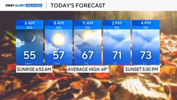
- Initial Cool and Misty Conditions: North Texas opened Monday morning with regional low temperatures ranging from the 40s across the Red River counties to the 50s throughout the Dallas-Fort Worth Metroplex, accompanied by isolated fog south and west.
- Low Rain Probability: Sky conditions remain predominantly cloudy with a minimal 10 percent chance of isolated showers across the central Metroplex and a 20 percent probability focused in southwestern counties.
- Unseasonably Warm Veterans Day: A sustained warming trend will push afternoon temperatures into the lower 80s by Veterans Day on Wednesday, 11 November 2026—significantly exceeding seasonal averages of 69°F.
- Favourable Event Conditions: Early morning Veterans Day celebrations will experience mild temperatures in the lower 60s (versus an average low of 48°F), providing clear atmospheric conditions for outdoor parades and community events.
- Post-Holiday Cold Front: A cold front passing through North Texas late on Veterans Day will initiate a gradual cooling trend, bringing high temperatures down into the mid-70s on Thursday and near 70°F by Friday, alongside a return to morning temperatures in the 40s.
Texas (Texas 24 News) November 9, 2026 – North Texas is set for a calm atmospheric week featuring a dramatic warming trend that will elevate temperatures into the lower 80s for Veterans Day before a autumn cold front brings cooler air late in the week. As reported by meteorologist Michael Autovino of CBS Texas, Monday morning regional readings opened in the 40s along the Red River border counties and the 50s across the Dallas-Fort Worth Metroplex. Despite widespread cloud cover and isolated early morning fog southwest of the urban core, meteorologists confirm a stable pattern will dominate North Texas over the coming days, guaranteeing unobstructed weather for outdoor holiday parades and outdoor public gatherings on Wednesday, 11 November 2026.
- What Are the Immediate Weather Conditions Facing North Texas Residents on Monday?
- How High Will Temperatures Rise for Veterans Day Celebrations?
- When Will the Approaching Autumn Cold Front Arrive in the Metroplex?
- Background of the Particular Development After the News
- How This Development Can Affect Public Events, Energy Grids, and Local Agriculture
What Are the Immediate Weather Conditions Facing North Texas Residents on Monday?
According to detailed morning telemetry released by meteorologist Michael Autovino of CBS Texas, North Texans woke up to a crisp start on Monday, 9 November 2026, necessitating light jackets across most urban and rural districts.
The immediate meteorological observations recorded across the region include:
- Temperature Gradients: Morning minimums registered in the mid-to-upper 40s across counties bordering the Red River, while inner Metroplex communities stabilized in the 50s.
- Visibilities and Fog: Isolated pockets of radiation fog formed early Monday morning, primarily positioned south and west of the main Dallas-Fort Worth urban corridor.
- Precipitation Probability: Widespread cloud cover dominated the regional sky, though precipitation limits remain low, with a 10 percent chance of brief showers in the Metroplex and a 20 percent chance across southwestern sectors.
As reported by Michael Autovino of CBS Texas, the minor atmospheric disturbance generating cloud cover will track eastward, leaving predominantly dry conditions across the region for the remainder of the work week.
How High Will Temperatures Rise for Veterans Day Celebrations?
As reported by CBS Texas, a mid-week warming trend will cause regional temperatures to climb significantly above late-autumn climatological averages across North Texas.
By Wednesday, 11 November 2026, daytime conditions will feel more akin to early autumn than mid-November, providing warm conditions for public ceremonies.
The thermal breakdown for Veterans Day compares against historical averages as follows:
- Morning Minimums: Temperatures will hover in the lower 60s during early morning hours—substantially warmer than the regional average low of 48°F.
- Afternoon Maximums: High temperatures will reach the lower 80s across the Metroplex—well above the typical seasonal benchmark high of 69°F.
- Parade Impact: As confirmed by meteorologist Michael Autovino of CBS Texas, “The weather will not get in the way of any morning parades or Veterans Day celebrations,” with zero operational disruptions expected for municipal events.
When Will the Approaching Autumn Cold Front Arrive in the Metroplex?
According to guidance published by Michael Autovino of CBS Texas, a weak cold front is scheduled to cross the Red River and move into North Texas late on Wednesday, 11 November 2026.
While the front may stall temporarily over central Texas, it will effectively halt the mid-week warming trend and re-establish a cooler airmass across the region.
The post-frontal temperature trajectory across North Texas includes:
- Thursday Transition: Daytime high temperatures will fall back into the mid-70s as northerly wind components settle over the area.
- Friday Highs: Afternoon maximum temperatures will drop further, topping out near 70°F under clearer skies.
- Weekend Morning Chills: By Friday morning, North Texas residents will experience a noticeable thermal drop, with morning minimums returning to the 40s across the Red River and Metroplex counties.
Background of the Particular Development After the News
North Texas during early November typically experiences transitional weather patterns governed by alternating continental polar air masses from Canada and maritime tropical air returning from the Gulf of Mexico. Climatological data for the Dallas-Fort Worth Metroplex lists average daily high temperatures dropping from 70°F in early November to the lower 60s by the end of the month, with average lows cooling into the mid-40s.
Throughout the preceding weeks of autumn 2026, North Texas recorded extended periods of sub-normal rainfall, leading to localized drought intensification across rural agricultural counties. While upper-level low-pressure systems moving across western Mexico occasionally push moisture into Texas, strong high-pressure ridging over the Southern Plains during early November 2026 suppressed significant convective activity. The arrival of the mid-week warming trend and subsequent dry cold front highlights the persistent dry regime governing the North Texas atmosphere this season.
How This Development Can Affect Public Events, Energy Grids, and Local Agriculture
The quiet, unseasonably warm mid-week weather followed by a late-week cold front will exert distinct short-term operational impacts across several sectors in North Texas.
Impact on Municipal Organisers and Veterans Day Attendees
For municipal event directors, military veteran organisations, and members of the public attending parades across Dallas, Fort Worth, Arlington, and surrounding cities, the unseasonably warm weather ensures high attendance without risk of rain delays. However, parade participants and spectators should prepare for warm afternoon conditions in the lower 80s, requiring hydration and sun protection during outdoor events.
Impact on Regional Energy Demand and ERCOT Operations
For regional power grid operators and municipal utility managers, the mid-week warmth will cause a temporary shift in residential energy consumption. While home heating demand will drop to zero during Tuesday and Wednesday afternoons, light air-conditioning usage may briefly spike across commercial buildings and residences as interior temperatures rise. The subsequent drop to the 40s by Friday morning will smoothly transition energy demand back toward morning heating loads without threatening grid stability.
Impact on Regional Agriculture and Drought Conditions
For agricultural producers and cattle ranchers across North Texas and the Red River basin, the continued lack of substantial rainfall during this quiet weather week prolongs soil moisture deficits. While the absence of freezing temperatures protects late-season forage, the low rain probabilities (10% to 20%) will do little to alleviate dry topsoil conditions ahead of the winter wheat planting and grazing season.