Key Points
- Seasonable Saturday Start: North Texas experienced a mild, seasonable start on Saturday morning, 24 October 2026, with morning temperatures settling primarily in the 50s.
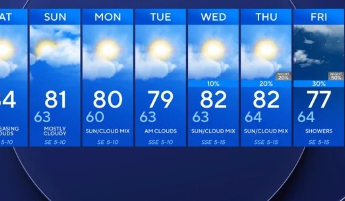
- Warm Weekend Forecast: Temperatures across the Dallas-Fort Worth (DFW) metroplex will remain consistently above average through the weekend, with afternoon highs climbing into the lower-to-middle 80s.
- Increasing Cloud Cover: Cloud systems building in from the west are projected to blanket the region, keeping skies overcast through Sunday, though dry conditions will persist into early next week.
- Upper-Level Trough System: An upper-level trough moving across the U.S. Great Plains by mid-week is expected to push a cold front into Texas, triggering elevated precipitation chances.
- Halloween Weekend Rain Outlook: Rain chances are set to increase steadily starting late Thursday, with showers and potential thunderstorms lingering into Halloween weekend.
Texas (Texas 24 News) October 24, 2026 — North Texas is enjoying a mild, dry weekend with daytime temperatures topping out in the 80s, but dynamic atmospheric changes are on the horizon. Regional meteorologists report that while high cloudiness will build across the DFW metroplex over the next 24 to 48 hours, dry conditions will prevail until late next week. An incoming upper-level trough sweeping across the Plains by mid-week is projected to bring a cold front and elevated rain chances. Local residents should prepare for unsettled weather, with showers and thunderstorms lingering into the Halloween weekend.
As reported by regional meteorological outlets covering North Texas, the Dallas-Fort Worth metroplex began Saturday, 24 October 2026, with mild conditions as morning temperatures settled comfortably into the mid-to-upper 50s. High temperatures across the region are forecast to climb into the lower-to-middle 80s throughout Saturday and Sunday, maintaining an above-average temperature trend that will extend into the start of the new workweek.
As reported by local weather authorities, cloud cover originating from the west will build across North Texas, creating overcast skies through Sunday. Despite the threatening appearance of the cloud cover, regional forecasters confirm that rain chances will remain negligible through the first half of the week, allowing residents across the DFW area to enjoy quiet weather before an upper-level trough pushes through the Great Plains to bring rain late Thursday and into the Halloween weekend.
How Will the Upper-Level Trough Shift North Texas Weather by Mid-Week?
As reported by regional weather tracking services, the extended period of warm and stable weather currently enveloping North Texas will undergo a notable shift by Wednesday and Thursday. Meteorologists are monitoring an upper-level trough of low pressure that is atmospheric conditions across the Central Plains.
As this trough advances eastward, it is expected to drag a cold front through Texas. The interaction between atmospheric moisture pulling in from the Gulf of Mexico and the forced ascent provided by the frontal boundary will increase rain and thunderstorm probabilities across the region, effectively breaking the ongoing stretch of dry weather.
What Is the Specific Rain and Thunderstorm Forecast for Halloween Weekend?
As reported by local meteorological updates, while exact rainfall totals and precise severe weather threats remain under evaluation due to long-range computer model variance, confidence is growing regarding precipitation timing.
Forecasters advise that rain chances will begin to climb late Thursday afternoon and evening. Showers look to be a strong possibility heading into Friday, 30 October, and Saturday, 31 October 2026, with embedded thunderstorms capable of producing localized downpours. Outdoor organizers and families preparing for Halloween activities across the DFW metroplex are encouraged to monitor updated forecast advisories as the front draws nearer.
Background of Autumn Weather Patterns in the Dallas-Fort Worth Metroplex
October in North Texas is historically recognized as a transitional month characterized by volatile shifts between lingering summer warmth and early-winter cold fronts. According to climatological records compiled by the National Weather Service (NWS) office in Fort Worth, normal late-October high temperatures in Dallas typically sit in the lower 70s, making the current string of 80-degree days notably above seasonal averages.
Historically, October also serves as a secondary severe weather season across North Texas. As strong upper-level troughs dip south from Canada and the Pacific Northwest, they collide with warm, moist air returning from the Gulf of Mexico. According to NWS Halloween climatology data, measurable precipitation has occurred on Halloween in Dallas-Fort Worth 37 times since historical record-keeping began, making late-October rain events a relatively common occurrence during autumn cold front passages.
How This Weather Development Will Affect Residents and Local Businesses
The return of rain and thunderstorm chances during Halloween week creates several tangible impacts for communities and commercial sectors across North Texas:
1. Families and Community Event Organizers
With showers and thunderstorms forecasted to linger into Halloween, family trick-or-treating plans and community festivals scheduled for Friday, 30 October, and Saturday, 31 October, face potential disruption. Event planners may need to arrange indoor backup venues, while parents should prepare wet-weather gear and monitor lightning advisories during evening trick-or-treating hours.
2. Retailers and Seasonal Agricultural Businesses
Pumpkin patches, corn mazes, and seasonal outdoor venues across North Texas rely heavily on dry weekend traffic to finalize autumn revenue. While the clear weather through Sunday will drive strong outdoor attendance, the mid-to-late week rain forecast could curtail outdoor foot traffic during the final days of the Halloween seasonal rush.
3. Regional Transportation and Commuters
After an extended stretch of dry road conditions, the arrival of rain late Thursday into Friday morning could lead to slick highway conditions and increased traffic delays across major DFW corridors, including Interstate 35E, Interstate 20, and US Highway 75. Transportation authorities recommend that commuters allow extra travel time toward the end of the workweek.